
RETECHNOLOGY PREMIUM MARKETPLACE RELATED PRODUCTS | WEBINARS | SPECIAL OFFERS


You are viewing our site as an Agent, Switch Your View:
Agent | Broker Reset Filters to Default Back to List3 Apps for Better Photo Lighting
May 01 2013
Lighting is one of the most important factors in photography. Nothing says "amateur photo" like a poorly lit shot.
The subject has been on our mind lately--we even published an article earlier this week on the importance of knowing your lighting sources. It focused mainly on interior shots, but we know how crucial the right lighting is to strong exterior photos, too.
That's why we were excited to learn about a type of app that can help you figure out the perfect time of day for taking exterior property photos. These apps work a lot like Google Maps, but instead of giving you directions, they provide you with the angle of the sun for any location you choose.
The map below came from a free web app called SunCalc. By entering an address, date, and time, I can find out exactly where the sun is in the sky and plan my photo shoot accordingly. The red line represents where the sun is located at sunset, and the yellow line shows where the sun rises in the morning. The orange line represents the sun at the time I specify. This is changed by moving the dot (the "sun") along the time slider at the top.

How It Works
How is this useful to the average photo-snapping agent? Let's say I wanted to take photos of the property from the map on page one. I need a primary exterior shot to upload to the MLS. I know that the abundant sunshine out here in California makes for a lot of golden tones to light exteriors with in the morning and evening. But I need to avoid taking photographs when the sun is directly behind the home I want to shoot--this creates dark silhouettes.
For well-lit photos, I need sunlight coming from behind me, streaming toward and illuminating my subject. From the map, I can find out when the sun will be hitting the property from the front and plan my photo shoot accordingly.
Here's where we run up the limitations of this free app, though. The map doesn't show you any features of the surrounding landscape, just a flat representation of the area. Since this is my neighborhood, I know that the grey area on the left side of the map is actually a mountain. If I shoot too close to sunset, the sun will be behind the mountain, casting a shadow on my property.
But don't worry yet--there's (another) app for that.
Paid Options
If the landscape in your area is relatively flat, the free web app may work just fine for you. For those of us surrounded by more untamed terrain, apps like LightTrac (iOS and Android) and The Photographers Ephemeris (iOS, Android, and Windows) give us a more in-depth view of an area's topography. Now you can see if mountains or other geography will affect your shots.
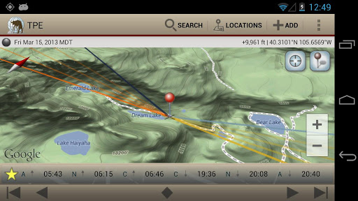
Both apps also work beautifully on tablets and sport advanced features like location saving, moon angle and elevation tracking, integrated compass views, and more. Now you never have to be in the dark about lighting conditions again!
Do you use any other apps in your real estate photography efforts? Which ones are your favorites? Let us know in the comments section below.